"Despite all our accomplishments, we owe our existence to a six-inch layer of topsoil and the fact that it rains"
This quote is from a speech by US radio broadcaster Paul Harvey given at the 1978 at the Future Farmers of America convention. This statement makes clear the inescapable truth that even today we remain existentially dependant on rain and this complex, dynamic and living thing we call soil.
In the Government’s Land Use Framework, published last month, soil is recognised as one of our greatest natural assets. Around 95% of our food depends on the soil, it is our most biodiverse ecosystem (arguably), our largest terrestrial carbon store and, it manages our water.
The Framework specifically commits to improving access to high-quality data, and for good reason, 6 of the 10 goals in the Environment Improvement Plan make reference to soil, highlighting its importance in how we tackle a broad range of environmental challenges.
Put simply, you can’t fix nature or have a resilient and sustainable food system, without having good soil. That’s why the National Soil Map is vital: access to the best soil data sets available is critical to ensuring soils are properly embedded in our thinking and decision-making.
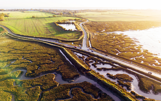
This month marks a significant milestone for soil, and in how we all can factor soils into our policy, research and decision making. The National Soil Map for England and Wales (NATMAP), alongside a range of additional LandIS (Land Information System) datasets, are now openly accessible to all through a new public portal LandIS Portal. This follows a collaborative effort by Defra and Cranfield University to make our most comprehensive soils datasets publicly available. Alongside this, Defra is publishing a new and updated version of the Agricultural Land Classification (ALC) map for England.
What is LandIS
LandIS is a comprehensive environmental information system containing the most extensive and detailed soil datasets available for England and Wales. Operated by Cranfield University for over 20 years - and originating from survey work dating back to the 1970s - it includes:
- NATMAP, the National Soil Map
- NATMAP Vector, a 1:250,000 map showing over 300 soil associations
- NATMAP Soilscapes, a simplified national soil map for broad applications
- NATMAP 1000 & 5000, gridded-vector soil reclassifications
- SOILSERIES datasets, offering detailed soil series properties
- Horizon data, describing physical and chemical properties of soil layers
- The National Soil Inventory, point based data on soil chemistry, structure, land use, and erosion
It is one of the largest systems of its kind in Europe and is recognised as the definitive source of national soils information in England and Wales. It has information from over 30,000 soil samples and more than 250,000 soil observations.
Users are now able use the LandIS data sets, restriction free, to undertake essential research and support decision making across sectors including agriculture, construction, conservation, climate science, hydrology, flood risk modelling and landscape management.
Why open access matters
Releasing these datasets will unlock significant benefits for environmental management, research, innovation, and policy. It will enable the development of new tools and decision-support systems to help deliver multiple Defra objectives. For the first time, public bodies, researchers, developers, land managers, and civil society organisations will be able to employ this data without restriction - supporting more innovative, evidence-based decision-making and wider scientific collaboration.
By making these datasets freely available, Defra and Cranfield University are delivering a step change in how soil evidence can be applied. This marks a significant milestone in Defra’s broader ambition to ensure high-quality data is accessible to all who need it to.
Bringing this data into the public domain is the result of individuals getting on the same page and overcoming an almost endless series of challenges to realise a common goal. Our sincere thanks therefore go the team at Cranfield for working with us and making this happen.
Predictive Agricultural Land Classification Map for England
The new Predictive ALC map replaces the outdated Provisional ALC map. It has been remodelled using the best available soils data from LandIS to provide greater consistency with current guidance and reliability.
The ALC System for England and Wales grades the quality of farmland for agricultural use. It currently informs planning policy to protect high quality agricultural land from loss to development and other land uses. It provides a framework for classifying farmland from Grade 1: excellent quality, to Grade 5: poor quality.
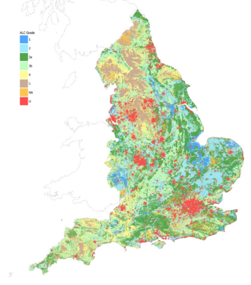
The Best and Most Versatile (BMV) land is defined as ALC Grades 1, 2 and 3a. The Predictive ALC map now includes the sub-division of Grade 3 into 3a and 3b allowing the extent of BMV land in England to be mapped. It is aligned with the Predictive ALC map for Wales supporting a harmonised approach across the nations.
The new predictive map continues to follow the MAFF 1988 methodology for the ALC System, which introduced the subdivision of grades 3a and 3b, and was updated in 2025. In the new map, around 20% of land has improved by one grade and less than 20% of land has decreased in grade as a result of the subdivision. The scale and resolution of the map mean it should only be used for strategic or indicative purposes, and it should not be used at field-scale. While the new map is a major improvement, it does not replace the need for detailed field-based ALC surveys, for example in planning applications. Instead, the map can help to target survey work to the most appropriate locations, particularly where land is predicted to be BMV.
In addition to this, Defra is currently undertaking a technical review of the ALC System which will be completed in 2028. This will allow new data and methodologies to be incorporated into the system to better classify agricultural land in the future.
An interim statistic for soil health in England is also now available through JNCC.
If you enjoyed reading this post, please subscribe to the Defra Environment Blog to receive updates on when we’ve shared more stories.
Leave a comment